Prev Up Top Next Contents
4.5 Sketch morphing
Therion can import scanned survey sketches both in the xtherion
map editor, as background images, and into the generated PDF outputs.
The imported sketched can be further morphed to adapt to the measured
cave points.
Sketch Morphing is a procedure to warp a sketch picture according to
measured point positions. The proper name, in the Image Processing
professional world should be "Sketch Warping", but cavers use the word
"Morphing", so we will stick with that.
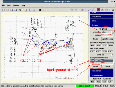
Fig. 63. Background sketch
4.5.1 Morphed sketches as background images
You need to morph a sketch picture according to the station points of a
scrap, and later import it as background image in the map editor.
The morphed sketch is saved in "xvi" (xtherion vector image) format.
You first open the xtherion map editor on the scrap
with the picture of the original (un-morphed) sketch as background image.
Then you select the scrap object, by selecting the scrap line in the
list of the "Objects" control. Next click on the "Insert sketch" button of
the "Scrap" control: the status bar shows a "Insert sketch" message.
Now if you click on the background image, the image is added to the list
of sketches to morph with this scrap data.
To generate the morphed sketches you need to export the map in xvi format.
In the "thconfig" file put the command
    export map \
      -fmt xvi \
      -o cave.xvi \
      -layout-sketches on
You can avoid to specify the format if you have an output filename with
extension "xvi". If you do not specify the name of the output file, therion
generates a file named "cave.xvi". You must put the layout option
"sketches on". Alternatively you can define a layout with that option and
add it to the export command,
    layout morph
      sketches on
    endlayout

    export map -o cave.xvi -layout morph
When you compile, ie, run therion, it generates the xvi file you requested.
If you insert it as background image ("Edit -> Insert image" menu, or
"Insert image" button of the "Background" control) you will get the
morphed sketch with the proper station points, into the map editor canvas.
From this point on you can continue to draft the cave map using the
morphed sketch.
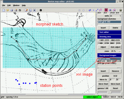
Fig. 64. Morphed sketch
4.5.2 Morphed sketches in the PDF output
To add a morphed sketch to you PDF output you must associate the
sketch to the scrap, the same way you did to export a xvi, and add the
layout sketches on option to the export command in the
configuration file.
4.5.3 Therion morphing algorithms.
There are four morphing algoriths implemented in therion:
- line
- linear
- plaquette
- point
By default the first is used. You can select a different algorithm by
specifying the command (in thconfig)
sketch-warp algorithm
where
algorithm is one of the four names above.
What is the difference among these algorithms ?
You do not need to know this. You can just try them out and use
whichever you find better. However some idea of the inner working
of the algorithms may help you to understand why the result you
are getting does not really look as you want.
The "line" algorithm changes a point position on the basis of
the inverse of the distances of the point from the survey legs
lines and stations.
The "linear" algorithm changes the sketch by a linear transformation
(translation + rotation), to adapt it as best as
possible to the two fartest stations.
The "plaquette" algorithm splits the sketch into triangles and
rectangles, using the centerline as skeleton, and warp each
of them bilinearly.
The "point" algorithm changes a point positions on the basis
of the inverse of the distances of the point from the station
points.
The differences between these algorithms can be seen in the image below.
In each case the positions of the station points have been emphasized
with green marks. The "linear" algorithm simply does a rototranslation
of the sketch without any deformation, and cannot adapt to the
measured points. The "point" tends to produce bulges on the cave
linear features (eg, walls) between the stations.
The "line" and the "plaquette" algorithms seem to do a fair job
since both these two algorithms
use the centerline shots as backbone for their job.
The "plaquette" algorithm is faster as it splits the image in patches
and map each patch one at a time, while the "line" algorithm
map each point by weighting the contributions to the map by all the survey
lines.
However the "plaquette" algorithm suffers from severe image distorsions,
when plaquettes pairs, in the sketch and in the map images, are
have rather different shape.
Therefore it is experimental, and it is advisable to use the "line"
algorithm (which is the default).
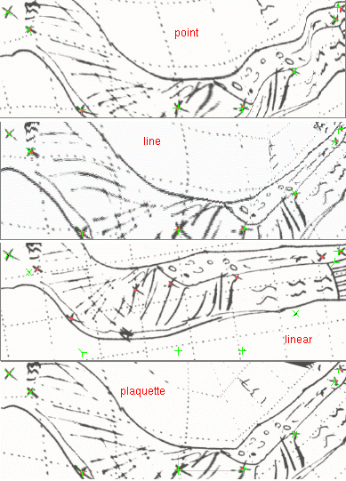
Fig. 65. Morphing algorithms
The morphing subdirectory of the samples in the therion
distribution has some complete examples of sketch morphing.
4.5.4 Extra points
If your survey data contain also the transversal dimensions (or other
measured or extimated distance) you can use this information in the
sketch morphing. to this aim you must tell therion where the
transversal dimensions end in the sketch, ie, where is the left and the
right points, or the up and down points, or whatever point you used
in the extra data.
You use points of type extra. If you do not specify any option,
therion will guess from which station is your measure, by taking
the closest station point (in the scrap). In case there is another
station closer to the extra point, you should use the option
-from followed by the station name. You can specify the value
of the dimension (option -dist or -value,
followed by a number, and optionally
a unit), or leave it to therion to figure it out from the
LRUD data in your survey.
4.5.5 Examples
therion users - Tue Feb 21 10:49:45 2012
Prev Up Top Next Contents
This work is licensed under a Creative Commons
Attribution-NonCommercial-ShareAlike 2.5 License.