Prev Up Top Next Contents
4.4 Loops
4.4.1 Loop closure
Loop closure is automatically done by therion when it process the
centerline data. All you have to do is to put in suitable equate
commands.
For example, suppose that there is a main cave passage with two side passages,
and you have surveyed the main passage, and the side passages separately.
Then you have three survey data files, and have drawn the respective maps.
When you assemble these together you must write the necessary
equate
commands (and the
join commands for the scraps), as in the
following code.
  input cave.th
  input cave2.th
  input cave3.th

  equate 2@cave 21@cave2
  equate 4@cave 23@cave2

  equate 3@cave1 31@cave3
  # equate 5@cave1 33@cave3

  join scrap1@cave1 scrap2@cave2 -count 2
  join scrap1@cave1 scrap3@cave3 -count 2
The result is shown in the figure below.
The side passages have been drawn at a offset to better distinguish them.
The connection straight lines go from the station points in the offset
maps to the station points in the main passage map.
This is shown for "cave2" in the figure. If you do not close
the loop, ie, you miss one equate command, the connection lines fail
to reach the proper station points in the main map, as in the case
of "cave3" in the figure.
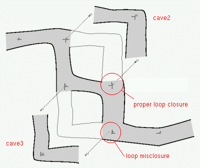
Fig. 60. Loop closure
4.4.2 Loops in extended elevation
In the extended elevation map the loop is
unrolled and there usually remains a gap between the end points, because
it is likely that the extents of the shots to the right does not
equate that of those to the left. The two station points at the gap
must be drawn at the same altitude, because they represent the
same survey station.
You can specify a starting station for the extended projection.
You do this with the "centerline" command extend start station,
for example extend start 1@survey2.
You may need to use also the extend ignore command. This commands
defines the station points that therion should not use to compute the
extended elevation map.
Finally the command extend hide tells therion not to show the
following shots in the extended elevation, and extend vertical
describes the shots for which only the vertical displacement
should be drawn.
For example, suppose that there is a survey with a side passage,
   ...
   2 3 10 90 0
   3 4 10 180 0
   ...
   21 22 10 90 30
   22 23 10 180 0
   23 24 10 90 -20
   ...

   equate 2 21
   equate 4 24
There is clearly a loop misclosure, and
therion carries out the
proper compensation of the shots, as far as the world position of the
station is concerned. When it comes to drawing the extended elevation map,
you must make choices and tell
therion about them.
For example if you want to put the points 2 and 21 at the same place,
then points 4 and 24 will be different. You must tell
therion not to
use the shot 23-24 in drawing the extended elevation.
You must also avoid putting a point of type "station" for the station
24 (option "-name 24") in the scrap, otherwise it will be placed to its
correct position in the extended section, and the piece of scrap
between 23 and 24 will be distorted.
The
extend command with the two stations of the shot is just what
you need (notice the order of the stations: the command says to ignore
the connection from "24" to "23" to build the extended map),
   extend start 6
   extend ignore 24 23
The result is shown in the figure below, in the lower part.
The map of the side passage has been displaced above the main passage
using the map offsetting feature of the
map command.
The first and last stations (namely 21 and 24) are connected to their
position in the overlay by using
map-connection points.
Finally a
map-connection line is drawn between points 4 and 24 (in the
overlay).
This is obtained by inserting a scrap in the source file, and adding the
map
m1 to the extended map.
  scrap s1 -proj extended
    point 0 0 station -name 4 -from 3
    point 100 0 station -name 24 -from 23
    line map-connection
      0 0
      100 0
    endline
  endscrap

  map m1 -proj extended
    s1
  endmap
If you want to draw the points "4" and "24" on the same spot and split
the map at the other end, at the points "2" and "21", you need to change
the starting station and the ignore shot. There must not be a point of
type "station" for station 21 in the scrap.
  extend start 1
  extend ignore 21 22
The result is shown in the upper part of the figure.
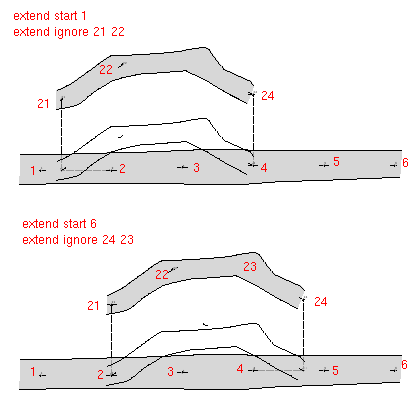
Fig. 61. Loop in extended elevation
If you do not write the extend ignore command therion uses
all the stations to generate the extended elevation map. Therefore
it stretches the shots so that the displacement between points 2 and 4
in the extended elevation, is the same as that between 21 and 24.
The outcome are stretched shots and enlarged passages, which is
probably not what you expected.
You might achieve the same result with extend ignore 23. In this case
therion ignores all the shots connected to station 23.
However if there are only three points you must specify the middle point
and the end point where you want to ignore the extend, otherwise
therion might choose the other endpoint.
Beware not to write extend ignore 24 after the equate 4 24 command.
Otherwise therion will ignore station point 4 when it generates the
extended elevation map.
Another error that might be a cause of concern to you is to write
extend ignore with a station point that is not the second to the last, or
the second, in the side branch. If you do this all the points between the one
you specifed and the end of the side passage can be extended in a wierd way.
If you specify the second to the last point, the last point is displaced with
respect to the corresponding point in the main passage. If you specify the
second point, the first point is displaced.
It may happens that you write an extend ignore A B but the drawing
comes out distorted as if the extend ignore command were not taken into
account. This depends on the order of the shots that therion follows
in building the map. Try to swap the two stations in the command, eg,
extend ignore B A, and things will go into place.
It is customary to draw a dotted (or dashed) line connecting the two
points to show that they denote the same survey station.
To do this you must provide a line of type
map-connection
in a scrap containing the two points. Supposing they belongs to different
surveys (which is the most common case) you write somethind like
  equate 1a@survey31 12@survey24

  centerline
    extend start 1a@survey31
  endcenterline

  scrap connetion1 -proj extended
    point   0 0 station -name 12@survey24 -from 11@survey24
    point 100 0 station -name 1a@survey31 -from 1@survey31
    line map-connection
        0 0
      100 0
    endline
  endscrap
The "map-connection" line does not need to be a straight segment,
but can be any curve. However a line with straight
(usually horizontal and vertical) segments is used to emphasize
that it is a "connection" line. For example, the following is
a "U" shaped line,
     line map-connection
         0 0
         0 20
       100 20
       100 0
     endline
The result is shown in the figure below, in which only the portion of
the survey with the map-connection line is displayed.
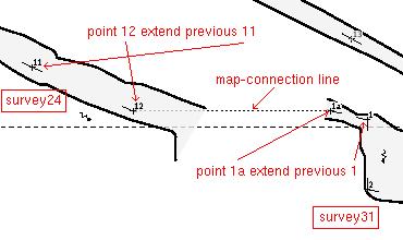
Fig. 62. Line: map-connection
4.4.3 The examples
therion users - Wed Jun 13 17:14:38 2012
Prev Up Top Next Contents
This work is licensed under a Creative Commons
Attribution-NonCommercial-ShareAlike 2.5 License.